BOOK WRITING 101: How To Make Progress Even When…

I arrived in Muskoka a week ago with a goal: to do what Charlotte Gray calls “walking around research” for the next two chapters I need to write. This means exploring resources that can only be found locally, interviewing local people who know the Muskoka Road and Muskoka history, combing through unpublished manuscripts in small-town libraries and driving parts of the road.

While travelling to Muskoka I lost my voice (and it stayed lost for five days.) I developed a deep, barking cough and felt my energy collapse like a snow-cone in this Ontario heat wave. I think I picked up a bug on an Air Canada flight just days before I left for Muskoka.

So much for interviewing people. So much for energy and focus. So much for working during the week and enjoying the weekend with friends and family at the cottage. Yesterday – the first day my energy felt normal, my voice was nearly recovered and, thanks to constantly drinking cough suppressant, I could allow myself to go out in public – I came up with a new plan. I’ve looked at my original goal, looked at my time remaining (five days) and divided the specific things I wanted to do into “Must Do” and “To Do Next Time” lists.

Must Do:

  • Get to Parry Sound District and at least visit two of the small communities that used to be on the road: Emsdale and Burk’s Falls. Find their local libraries and see if there is any primary source material there: family histories, memoirs, diaries that relate anyone’s direct experience with the road or homesteading on the road.
  • Arrange to meet the people in Muskoka who I’ve previously emailed or phoned and who have information to share that can help me.

To Do Next Time

  • Everything else that was on the list: all the other towns in Parry Sound District, all the other libraries and historical sites, all the driving of the road.

OK, maybe the original list was a bit ambitious for a two-week timeframe. That would be typical of me. Maybe I have to spend more of August in Muskoka than I planned. And maybe September too.

Well, I can think of worse consequences from a summer cold.

At least I had this to look at while recuperating:
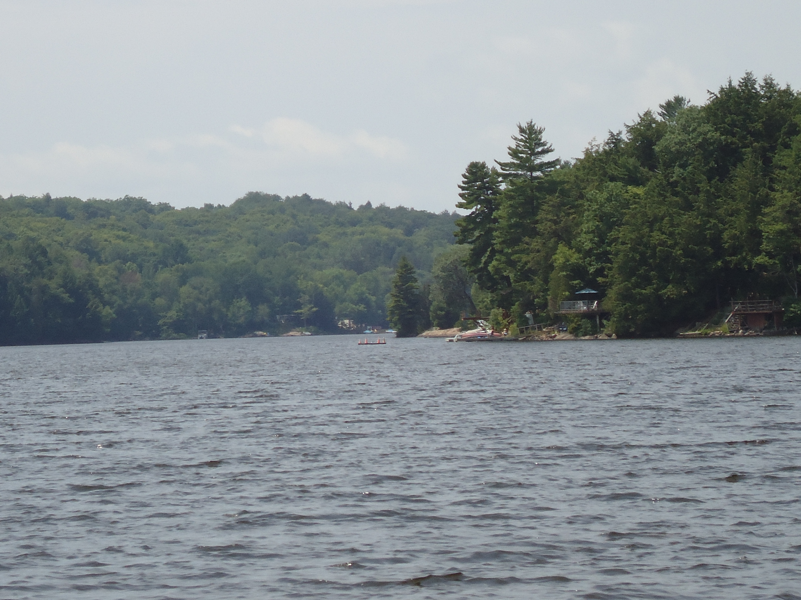
View from the dock

Fun Facts About Ontario Roads: 1700 to 1903

I bet you didn’t know there are fun facts about Ontario roads! Neither did I, until I started researching the Muskoka Colonization Road. Here is some of what I learned from a book called Footpaths to Freeways: The Story of Ontario’s Roads, published in 1984 by the Ontario Ministry of Transportation and Communications. More to come in a later post. Enjoy!

Ontario’s first “roads” were actually its rivers and lakes, linked where necessary by portages (meaning “carrying place”) and used by natives and fur traders for hundreds of years.

Most roads in Ontario were dirt until well into the 20th century.

“Corduroy Roads” were made by laying logs across over dirt roads and were used to cross swamps and bogs. A big improvement to dirt and corduroy roads were “macadamized” (gravelled) roads, used from the mid-1830s. Another innovation from about the same time was planked roads, which cost about ¼ that of gravel roads. Lumber was cheap and readily available, but plank roads got torn up by horses’ hooves and had to be replaced more often.

“Statute labour” was introduced by the government in 1793, compelling landowners to provide up to 12 days’ labour a year for road and bridge construction, based on the assessed value of their property. This law has still not been repealed by the Ontario government, so is still in effect in any township that has not formally abolished it.

The original purpose of Yonge Street in Toronto was as a military road leading north, opening a route to the upper Great Lakes. As of August 1794 Yonge Street had been partly “opened” (cut out of the bush) but construction stopped because of the threat of American attack and the need to take the soldiers who were building the road to the Niagara Frontier.

Toll roads have been in use in Ontario since 1825.

In 1896, A.W. Campbell, Ontario’s Instructor in Road-Making stated in his report: “By far the greatest part of the mileage of the province is mud, ruts and pitch-holes.”

The first car owner in Canada was John Moodie of Hamilton. In 1898, he bought a single cylinder, gasoline-powered “runabout” manufactured by the Winton Motor Carriage Company of Cleveland.

Early automobiles were known by their detractors as “devil’s carts” “stink wagons” and “juggernauts of the streets”.

High-performance cars of 1902 could travel at a staggering 20 miles per hour [32 kph], prompting a maximum speed limit of 15 mph [24 kph] to be established in 1903. Early speed traps included two constables placed one-tenth of a mile apart, to clock each passing car using a stopwatch. To stop a speeding car, the police simply threw a plank studded with nails into the path of an oncoming motorist. If the driver could stop before reaching the plank, he was driving within the speed limit and was free to go. If not – hopefully he had a spare tire.

FARMING IN MUSKOKA: First You Burn the Field

As I harvested the first of the lettuce from my garden this week, I thought about the pioneers living along The Muskoka Road. The first settlers to take up the “free grant lands” arrived in October 1859. They hauled themselves up the rock ridge just north of the Severn River and then scouted out an allotted 100 acres for their farmsteads. Only the lots directly adjacent to the road had been surveyed, and none of the families realized at the time that these initial 94 lots between Severn River and McCabe’s Landing (Gravenhurst) were some of the worst in the district for farming.

Near Lot 19 Morrison Twp on the Muskoka Road

Of course it was too late in the season to plant anything. The job at hand was to chop out a small clearing and build a shanty for the winter. But most settlers also cut the underbrush from the first acre or two in preparation for creating a field to plant in spring. They piled up the underbrush and then over the winter chopped down some of the large trees.  Using axes. Against old growth pines, some of which were 100 feet high and 7 feet in diameter. They cut the trunks of the trees into lengths of about 15 feet and heaved them onto the underbrush.

In May, when the brush was dry enough to burn, and on a day when the wind was blowing away from the new shanty, the pioneer collected some dry hemlock and birch bark and a piece of punk (dry, rotten wood). Crouching over this, he scratched his knife on a flint stone to strike a spark, then watched as a thin thread of smoke snaked up from the punk. With some blowing, the fire caught the bark and spread, until it was a great billowing mass. Funnels and forks of flames raced through the dry tinder. The pioneer moved carefully among the piles of brush, lighting each one until the acre blazed in one great inferno. By nightfall the fire died down, leaving the earth and skeletal stumps of trees black and scorched. The great piles of brush were gone, but charred logs remained and would have to be picked up, piled and burned again over the course of several days. Only the burnt stumps of the largest trees were left standing. It took about seven years before the roots had rotted enough to be pulled out. So wherever there was room between the tree stumps, the pioneers planted their crops of potatoes, garden produce, corn and buckwheat.

Salad, anyone?

THE MUSKOKA COLONIZATION ROAD: Tree Stumps and Ridges and Dirt, Oh My!

When we drive almost anywhere in the world today, we do so expecting good roads. Paved roads, ones that have been engineered for safety, with curves that are easy to negotiate. We are affronted by pot-holes and cracks in the asphalt. We expect that obstacles like rivers, undeveloped land or rock ridges are removed or bridged so we can get to where we are going as quickly and easily as possible.  Roads for the most part are straight, level and paved.

Until the 1930s, The Muskoka Colonization Road was anything but. Rivers and lakes, when they couldn’t be avoided, were crossed by simple wooden bridges that tended to sway alarmingly and get washed out in spring floods. Settlers hacked the road out of very dense forest, chopping down trees where the surveyors’ chains marked the route. They left the tree stumps to rot, which made for a pockmarked obstacle course that was often easier for people to walk through than for horses to pull a wagon through. There was no engineering at the time that could cut through a granite ridge, so the road went over or around these – often, since granite ridges are as plentiful as mosquitoes in Muskoka.

Here’s a view of Highway 11 just north of the Severn Bridge, heading north.

See how the rock-cut makes the road nice and flat for the cars? When you’re speeding along this stretch of the highway, almost at the cottage, I bet you don’t even notice the rock-cut. Which is too bad, because it’s gorgeous. But it’s also a feat of engineering that would stun the average Muskoka pioneer. That poor person had to haul all his belongings up the ridge and down the other side. At this exact spot – the southern boundary of the Muskoka District and near the official start of the Muskoka Road – the ridge is over 15 metres high.

No wonder hundreds of potential settlers took one look and turned around!

CENSUS INFORMATION: 1871 and 2011

Spring in my Garden

It’s spring, and the government’s mind turns to: census-taking! That’s true in 2011 and was the same in 1871. The census is of course a great source of data for a researcher like me. The census has also recently been controversial – the Chief Statistician resigned over the government’s decision to shorten the census this year and make part of it voluntary.

This week I filled out the 2011 census – online, a very cool option – and also spent time in the 1871 census of Muskoka. I noticed a few interesting differences between the two census questionnaires. Which I suppose is to be expected as they’re 140 years apart. 

For instance, we no longer ask everyone how many acres they have under crop. Or what livestock or how many carriages they own. Or if anyone in the household is “deaf, dumb, blind or of unsound mind.” Questions about “Daily Living” do form part of the “National Household Survey” (the optional part of the 2011 census,) although the method of questioning about that kind of thing is now much more polite: “Does this person have any difficulty hearing, seeing, communicating, walking, climbing stairs, bending, learning or doing any similar activities?”

The question of religion is not part of the 2011 short form census. Nor is ‘profession, occupation, or trade’. Nor is ethnic background.

Marital status has gotten quite a bit more complicated. In 1871 you were either single, married or widowed. In 2011, you could be:

  • never legally married
  • legally married (and not separated)
  • separated (but still legally married)
  • divorced
  • widowed… OR (asked in a separate question)
  • living with a common-law partner.

In 1871 there was no question about what language you spoke – fascinating for a country of immigrants. Speaking of which, I’m researching the 1871 census records of two immigrant families:

  1. The Simintons of Morrison township. They were among the very first settlers along the Muskoka Road and had been singled out in the Provincial Land Agent’s 1859 report as being “particularly intelligent and industrious.” I think by 1871 they had abandoned their land and fled to Manitoba.
  2. Ira Fetterley of Chaffey township. I found only one reference that specifies the Muskoka Road ended at his farm in 1865. All others say it ended somewhere in the vicinity of Lake Vernon. I would much rather learn about Ira Fetterley and use his story to talk about the end of the road! So I am hoping the enumerator made some kind of reference to the government road in a note on the Fetterley record.

That is another difference, 140 years later: there is no place to make a note!

IN PRAISE OF PRIMARY SOURCE MATERIAL

This week I’ve continued to thoroughly enjoy writing Chapter 5. Partly because it’s another chapter full of big developments for both Muskoka and the Muskoka Colonization Road, but mostly because I have plenty of primary source material.

Primary source material includes all kinds of eye-witness accounts, recorded in diaries, memoirs, contemporary newspaper reports, letters. It is to a non-fiction book what compost is to a garden. You can produce good stuff without it, but with it your results are stronger and more colourful.

In this chapter I’m writing about a major upgrade to the first 19 kilometres of the Muskoka Road. This topic could be kind of technical and boring – we’re talking about gravelling and planking here – except that I have the 1870 engineering specs that the government sent out and the engineering drawing hand-done by the supervising engineer. The specs include details like this for the gravelled part of the road:

  • “If broken stone is used it will be so broken that the largest will pass through a ring of 2 1/2 inches [6 cm] in diameter.” I love this! So that must mean that the supervising engineer – the wonderfully named  Thomas Nepean Molesworth – carried such a ring with him?

And for the planked portion of the road:

  • “Pine or hemlock planks 8 feet by 3 inches [2.4m X 7.6cm] resting on wood supports 12 inches [30cm] wide by 1 foot [30cm] thick, fastened thereto with five foot [1.5m] cut spikes driven diagonally at each end of a plank.”

Sounds like a pretty sturdy road, right? Not really. Because we have the letters written by Harriet Barbara King, a self-described “emigrant lady” who took a stagecoach up that same stretch of road the summer following its re-engineering. Here is what she had to say:

“Oh! The horrors of that journey! The road was most dreadful – our first acquaintance with ‘corduroy’ roads… Your brother with his arm round me the whole way (I clinging to the collar of his coat), could hardly keep me steady as we bumped over every obstacle. In the worst places I was glad to shut my eyes that I might not see the danger.”

The Muskoka Colonization Road was a bone-jarring, dangerous, painful route into the district for almost 80 years. I can tell you that, or I can show you that, through eye-witness accounts from primary source material. The humus for my story!